UPDATE: pkg API has changed - updated the post below to work with the current CRAN version, submitted 2016-08-02
I was at a hackathon focused on Ocean Biogeographic Information System (OBIS) data back in November last year in Belgium. One project idea was to make it easier to get at data based on one or more marine regions. I was told that Marineregions.org is often used for shape files to get different regions to then do other work with.
During the event I started a package mregions. Here I’ll show how to get different marine regions, then use those outputs to get species occurrence data.
We’ll use WKT (Well-Known Text) to define spatial dimensions in this post. If you don’t know what it is, Wikipedia to the rescue: https://en.wikipedia.org/wiki/Well-known_text
Install
install.packages("mregions")
devtools::install_github("iobis/robis")
Or get the dev version
devtools::install_github("ropenscilabs/mregions")
library("mregions")
Get list of place types
res <- mr_place_types()
head(res$type)
#> [1] "Town"                      "Arrondissement"
#> [3] "Department"                "Province (administrative)"
#> [5] "Country"                   "Continent"
Get Marineregions records by place type
res <- mr_records_by_type(type = "EEZ")
head(res)
#>   MRGID                                            gazetteerSource
#> 1  3293 Maritime Boundaries Geodatabase, Flanders Marine Institute
#> 2  5668 Maritime Boundaries Geodatabase, Flanders Marine Institute
#> 3  5669 Maritime Boundaries Geodatabase, Flanders Marine Institute
#> 4  5670 Maritime Boundaries Geodatabase, Flanders Marine Institute
#> 5  5672 Maritime Boundaries Geodatabase, Flanders Marine Institute
#> 6  5673 Maritime Boundaries Geodatabase, Flanders Marine Institute
#>   placeType latitude longitude minLatitude minLongitude maxLatitude
#> 1       EEZ 51.46483  2.704458    51.09111     2.238118    51.87000
#> 2       EEZ 53.61508  4.190675    51.26203     2.539443    55.76500
#> 3       EEZ 54.55970  8.389231    53.24281     3.349999    55.91928
#> 4       EEZ 40.87030 19.147094    39.63863    18.461940    41.86124
#> 5       EEZ 42.94272 29.219062    41.97820    27.449580    43.74779
#> 6       EEZ 43.42847 15.650844    41.62201    13.001390    45.59079
#>   maxLongitude precision            preferredGazetteerName
#> 1     3.364907  58302.49   Belgian Exclusive Economic Zone
#> 2     7.208364 294046.10     Dutch Exclusive Economic Zone
#> 3    14.750000 395845.50    German Exclusive Economic Zone
#> 4    20.010030 139751.70  Albanian Exclusive Economic Zone
#> 5    31.345280 186792.50 Bulgarian Exclusive Economic Zone
#> 6    18.552360 313990.30  Croatian Exclusive Economic Zone
#>   preferredGazetteerNameLang   status accepted
#> 1                    English standard     3293
#> 2                    English standard     5668
#> 3                    English standard     5669
#> 4                    English standard     5670
#> 5                    English standard     5672
#> 6                    English standard     5673
Get and search region names
(res <- mr_names())
#> # A tibble: 676 x 4
#>                              name
#>                             <chr>
#> 1           Morocco:elevation_10m
#> 2          Emodnet:emodnet1x1grid
#> 3                    Emodnet:grid
#> 4                     Morocco:dam
#> 5             WoRMS:azmp_sections
#> 6    Morocco:accomodationcapacity
#> 7          Morocco:admin_boundary
#> 8  Lifewatch:ovam_afvalverwerking
#> 9          Eurobis:eurobis_points
#> 10                  Morocco:roads
#> # ... with 666 more rows, and 3 more variables: title <chr>,
#> #   name_first <chr>, name_second <chr>
mr_names_search(res, q = "IHO")
#> # A tibble: 5 x 4
#>                                   name
#>                                  <chr>
#> 1                    MarineRegions:iho
#> 2 MarineRegions:iho_quadrants_20150810
#> 3                     World:iosregions
#> 4       MarineRegions:eez_iho_union_v2
#> 5                   Belgium:vl_venivon
#> # ... with 3 more variables: title <chr>, name_first <chr>,
#> #   name_second <chr>
Get a region - geojson
res <- mr_geojson(name = "Turkmen Exclusive Economic Zone")
class(res)
#> [1] "mr_geojson"
names(res)
#> [1] "type"          "totalFeatures" "features"      "crs"
#> [5] "bbox"
Get a region - shp
res <- mr_shp(name = "Belgian Exclusive Economic Zone")
class(res)
#> [1] "SpatialPolygonsDataFrame"
#> attr(,"package")
#> [1] "sp"
Get OBIS EEZ ID
res <- mr_names()
res <- res[grepl("eez", res$name, ignore.case = TRUE),]
mr_obis_eez_id(res$title[2])
#> [1] 84
Convert to WKT
From geojson or shp. Here, geojson
res <- mr_geojson(key = "MarineRegions:eez_33176")
mr_as_wkt(res, fmt = 5)
#> [1] "MULTIPOLYGON (((41.573732 -1.659444, 45.891882 ... cutoff
Get regions, then OBIS data
Using Well-Known Text
Both shp and geojson data returned from region_shp() and region_geojson(), respectively, can be passed to as_wkt() to get WKT.
shp <- mr_shp(name = "Belgian Exclusive Economic Zone")
wkt <- mr_as_wkt(shp)
library('httr')
library('data.table')
args <- list(scientificname = "Abra alba", geometry = wkt, limit = 100)
res <- httr::GET('https://api.iobis.org/occurrence', query = args)
xx <- data.table::setDF(data.table::rbindlist(httr::content(res)$results, use.names = TRUE, fill = TRUE))
xx <- xx[, c('scientificName', 'decimalLongitude', 'decimalLatitude')]
names(xx)[2:3] <- c('longitude', 'latitude')
Plot
library('leaflet')
leaflet() %>%
  addTiles() %>%
  addCircleMarkers(data = xx) %>%
  addPolygons(data = shp)

Using EEZ ID
EEZ is a Exclusive Economic Zone
(eez <- mr_obis_eez_id("Belgian Exclusive Economic Zone"))
#> [1] 59
You currently can’t search for OBIS occurrences by EEZ ID, but hopefully soon…
Dealing with bigger WKT
What if you’re WKT string is super long? It’s often a problem because some online species occurrence databases that accept WKT to search by geometry bork due to limitations on length of URLs if your WKT string is too long (about 8000 characters, including remainder of URL). One way to deal with it is to reduce detail - simplify.
install.packages("rmapshaper")
Using rmapshaper we can simplify a spatial object, then search with that.
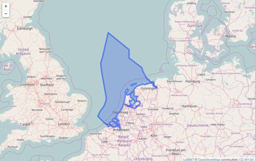
shp <- mr_shp(name = "Dutch Exclusive Economic Zone")
Visualize
leaflet() %>%
  addTiles() %>%
  addPolygons(data = shp)

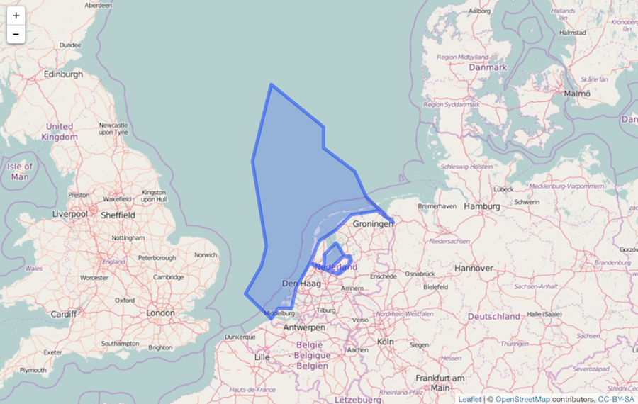
Simplify
library("rmapshaper")
shp <- ms_simplify(shp)
It’s simplified:
leaflet() %>%
  addTiles() %>%
  addPolygons(data = shp)

Pass to GBIF
if (!requireNamespace("rgbif")) {
  install.packages("rgbif")
}
library("rgbif")
occ_search(geometry = mr_as_wkt(shp), limit = 400)
#> Records found [2395936]
#> Records returned [400]
#> No. unique hierarchies [17]
#> No. media records [3]
#> Args [geometry=POLYGON ((7.2083632399999997 53.2428091399999985,
#>      6.6974995100000001 53.4619365499999972, 5.89083650, limit=400,
#>      offset=0, fields=all]
#> # A tibble: 400 x 102
#>                     name        key decimalLatitude decimalLongitude
#>                    <chr>      <int>           <dbl>            <dbl>
#> 1  Haematopus ostralegus 1265900666        52.13467          4.21306
#> 2          Limosa limosa 1265577408        53.03249          4.88665
#> 3       Corvus splendens 1269536058        51.98297          4.12982
#> 4       Corvus splendens 1269536065        51.98297          4.12982
#> 5       Lanius excubitor 1211320606        52.57223          4.62569
#> 6       Lanius excubitor 1211320862        52.67419          4.63645
#> 7       Lanius excubitor 1211320806        53.05790          4.72974
#> 8       Lanius excubitor 1211321040        52.57540          4.63651
#> 9       Lanius excubitor 1211320590        52.41180          5.19500
#> 10      Lanius excubitor 1211320401        52.57535          4.63654
#> # ... with 390 more rows, and 98 more variables: issues <chr>,
#> #   datasetKey <chr>, publishingOrgKey <chr>, publishingCountry <chr>,
#> #   protocol <chr>, lastCrawled <chr>, lastParsed <chr>, extensions <chr>,
#> #   basisOfRecord <chr>, taxonKey <int>, kingdomKey <int>,
#> #   phylumKey <int>, classKey <int>, orderKey <int>, familyKey <int>,
#> #   genusKey <int>, speciesKey <int>, scientificName <chr>, kingdom <chr>,
#> #   phylum <chr>, order <chr>, family <chr>, genus <chr>, species <chr>,
#> #   genericName <chr>, specificEpithet <chr>, taxonRank <chr>,
#> #   dateIdentified <chr>, coordinateUncertaintyInMeters <dbl>, year <int>,
#> #   month <int>, day <int>, eventDate <chr>, modified <chr>,
#> #   lastInterpreted <chr>, references <chr>, identifiers <chr>,
#> #   facts <chr>, relations <chr>, geodeticDatum <chr>, class <chr>,
#> #   countryCode <chr>, country <chr>, rightsHolder <chr>,
#> #   identifier <chr>, informationWithheld <chr>, verbatimEventDate <chr>,
#> #   datasetName <chr>, gbifID <chr>, collectionCode <chr>,
#> #   verbatimLocality <chr>, occurrenceID <chr>, taxonID <chr>,
#> #   license <chr>, recordedBy <chr>, catalogNumber <chr>,
#> #   http...unknown.org.occurrenceDetails <chr>, institutionCode <chr>,
#> #   rights <chr>, eventTime <chr>, identificationID <chr>,
#> #   individualCount <int>, continent <chr>, stateProvince <chr>,
#> #   nomenclaturalCode <chr>, locality <chr>, language <chr>,
#> #   taxonomicStatus <chr>, type <chr>, preparations <chr>,
#> #   disposition <chr>, originalNameUsage <chr>,
#> #   bibliographicCitation <chr>, identifiedBy <chr>, sex <chr>,
#> #   lifeStage <chr>, otherCatalogNumbers <chr>, habitat <chr>,
#> #   georeferencedBy <chr>, vernacularName <chr>, elevation <dbl>,
#> #   minimumDistanceAboveSurfaceInMeters <chr>, dynamicProperties <chr>,
#> #   samplingEffort <chr>, organismName <chr>, georeferencedDate <chr>,
#> #   georeferenceProtocol <chr>, georeferenceVerificationStatus <chr>,
#> #   organismID <chr>, ownerInstitutionCode <chr>, samplingProtocol <chr>,
#> #   datasetID <chr>, accessRights <chr>, georeferenceSources <chr>,
#> #   elevationAccuracy <dbl>, depth <dbl>, depthAccuracy <dbl>,
#> #   waterBody <chr>